
Singapore Railways
Please note:- this is a historical site only. For current information, timetables and tickets please visit the official website of the appropriate railway.
KTMB is at http://www.ktmb.com.my/
Overview
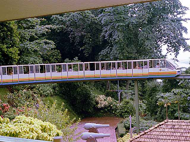
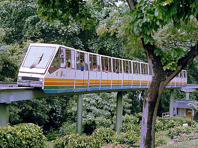
This page was originally created as an overflow for my Malayan Railways site and should be used in conjunction with it. For those not familiar with the region Singapore is an island state, roughly the size and shape of the Isle of Wight, situated at the southern tip of the Malay peninsular. The metre-gauge Malayan Railway (Keretapi Tanah Melayu) enters Singapore via the Johore Causeway at Woodlands, where the immigration and customs facilities are now located, and runs across the centre of the island, via Bukit Timah, to a terminus at Tanjong Pagar, adjacent to the container terminal on the south-western edge of the city. At Bukit Timah there is a passing loop, and it was also a junction for a freight only branch to Jurong, which closed in the mid 1990s. Steam finished on the island in 1972 and most of the early diesels have now gone also. Scroll down for a history of Singapore Railways. In the mid 1980's a Mass Rapid Transit (MRT) system was commenced and is still expanding. It runs underground in the city but on the surface or elevated throughout the rest of the island. The trains are driverless 6-car electric sets but there are also some diesel shunters and Bo-Bo units for permanent way work. There are monorail systems (for pleasure purposes) on Sentosa Island and at the Jurong Bird Park. On the industrial front there was a harbour railway at Loyang, an admiralty railway from Woodlands to Sembawang, several sidings to military depots, private sidings with a diesel shunter in Jurong and an extensive system in the Port of Singapore, which had its own fleet of steam, and later diesel, shunters. One of the dry docks in Singapore also boasted a steam crane on broad gauge tracks, this was later preserved on Sentosa Island in the Maritime Museum until 2002 and some of the artifacts are now installed along the Harbour Front precinct. They include a lighthouse, an anchor, a harpoon, a pair of gate posts and the steam crane .
.I have a few photographs from all these locations and some can be accessed via the thumbnails below. Many others are already included in the Malayan Railway site.
Loyang ->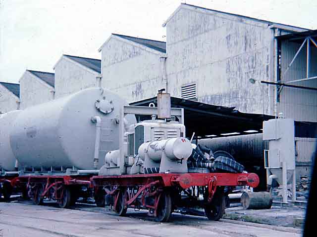 Jurong ->
 Port of Singapore ->
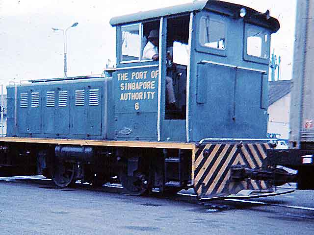
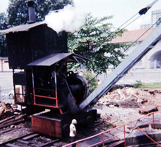
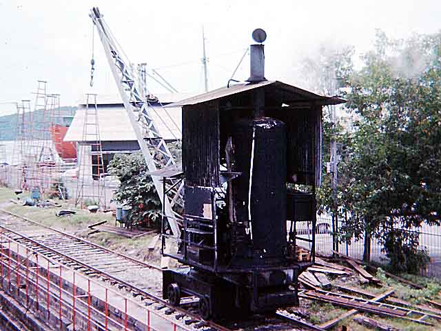
Steam crane at
work->
![]()
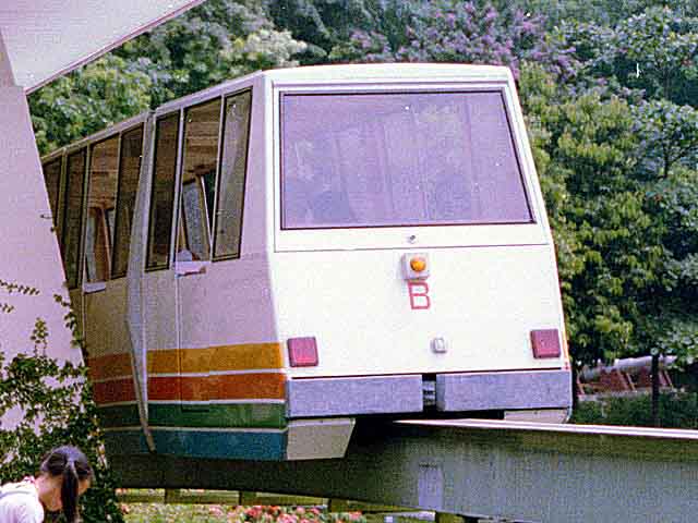
Sentosa monorail
->
![]()
More pictures can be found here.
History
The first indication I can find of any railways in Singapore is a picture taken in the 1870's of bullock carts in the docks which has a single track line running through the foreground. This appears in "Singapore then and now, volume 2" by Ray Tyers. In the same book is a picture of Tanjong Pagar Road in 1892 showing a double track tram line junction complete with steam trams. There is also a picture of the Tank Road terminus (see below) taken in 1910. A steam tramway was operated (one report suggested to Kranji but this was actually a plan which did not come to completion - see The Kranji Electric Tram) from 1885-1894 and there were two electric tramway experiments: along a block of track at the docks in September, 1891, and along a mile of track on "The Kranji Electric Line" in September, 1892. This was in fact a special track laid for the purpose on ground owned by the Sultan of Johore near Kranji. An electric tram system was opened in the city on 25th July 1905, and by 1907 was operating 60 trams on more than 26 miles of track. All rail operation ended on April 9, 1927, although I understand electric trolley buses operated for a lot longer.
The first record I can find of locomotives being supplied to Singapore is in 1877 when Dick and Stevenson supplied two 0-4-0ST shunters numbered 1 & 2. They were apparently sent to the Tanjong Pagar Dock Company steam railway which was on their mile-long wharf which, according to an 1880 report "essentially aids the labour of unloading vessels", of which 40 could be accommodated at one time. I now have a lot more details of this line along with maps and published statements by members of the Board in local newspapers. These updates will be added to my Industrial page.
Click here for details of the steam tram locomotives.
The National Archives of Singapore have numerous pictures, many of which are duplicated several times and these have wildly fluctuating dates. For example, one picture has been posted several times with dates ranging from 1890 to 1930. The information I have so far comes from a number of sources and there are some discrepancies in the details but I have already come across a number of dated photographs which will prove invaluable in creating a more accurate picture. I also have copies of old newspaper articles which provide accurate dates of notable events.
I have created a separate page for tram systems but am still searching for more information and pictures. Any information or pictures which can be used on this site would be most welcome, please send by e-mail.
I have come across two different versions of the history of the first railway; the first was based on original ideas and subsequent assumptions and should be ignored.
Early plans/ideas, not acted on.
The following has appeared in some history books but was an idea or plan which was not acted upon. "In 1871, plans were made for a railway from New Harbour (now Keppel Harbour) to the town, but it was not until 30 years later that a line was actually laid down from Telok Blangah over Craig Hill to the People's Park (off New Bridge Road). Thence it was continued across the river by way of Pulau Saigon, and along Tank Road, Cuppage Road and Clemenceau Avenue to Newton Circus. In 1902, it reached the Johore Straits at Kranji." The plan is true but the rest was an assumption based on early ideas and a final layout some 30-40 years later. Subsequent research and information has proved it to be misleading, as the first railway was built from Singapore to Woodlands, opening in 1903, while the extension from Singapore to the docks did not open until 1907. My thanks to Margie Hall for supplying the corrections. A reading of old newspapers of the day has provided a great deal of information on the early plans from the 1870s which will appear here eventually, but apart from the dock railway and tramways mentioned above no other railways are known to have existed in Singapore in the nineteenth century.
Correct version, updated December 2010.
The Straits Settlements Acting Colonial Engineer carried out a traffic survey in 1896 and his report follows:-
From the Singapore Free Press, 30 October 1896, page 2.
THE SINGAPORE KRANJI RAILWAY
Report by Captain F. J. Anderson, R. E., Acting Colonial Engineer, on the Statistics of Traffic passing over the Singapore Kranji Line of Road, during the year ended June 30th 1896.
Collection of Statistics.
1. The distance from Kandang Kerbau (Singapore) to Kranji is 13½ miles and the level of traffic was recorded at 3 points, viz., Wayang Satu, Bukit Timah and Bukit Mandai Police Stations, situated at 2N, 6 and 11I miles, respectively, from the Singapore terminus. The details of the traffic were taken under the following headings:-
Foot passengers with and without bundles.
Hack gharries, loaded, with number of occupants, distinguishing European, Eurasian and Native.
Hack gharries, empty.
Coaches, with number of occupants.
Private carriages, with number of occupants.
Rikishas, loaded, with number of occupants.
Rikishas, empty.
Bullock-carts, with contents.
Cattle.
Explanation of Totalling.
2. In estimating the traffic, all foot passengers have been counted as 3rd class, while occupants of hack gharries, coaches, private carriages and Rikishas have been classed, according to nationality, Europeans, 1st; Eurasians, 2nd; and Natives, 3rd; and no account has been taken of anything else. Occupants of bullock carts have been left out of consideration.
The nett result is that, taking the passing in both directions, we have a total for the year of:-
|
|
Wayang Satu |
Bukit Timah |
Kranji |
|
1st class Europeans |
38,155 |
5,096 |
6,314 |
|
2nd class Eurasians |
7,240 |
3,514 |
2,613 |
|
3rd class - Natives |
641,639 |
273,739 |
163,503 |
The goods traffic being small has been left out of the calculation altogether.
Probable Traffic
The accompanying return marked A shows the figures, month by month.
3. In considering the question of a mere (metre?) gauge railway, I have thought it advisable to assume that only 50 per cent. of the 3rd class and 75 per cent. of the 1st. and 2nd classes will use the line, the through fares being fixed at 80 cents, 40 cents, and 20 cents, respectively, according to class, compared with the existing bus fare of 50 cents and 35 cents, according to seats, and rikisha fare of 72 cents, or 90 cents for two. I have purposely fixed the fares low in order to compete with the rikisha traffic.
I have further assumed that the above proportions of the passengers passing each of the above three points of observation would traverse one-third of the line, or, in other words, pay one-third of the above fares. As I have allowed for five stopping points in addition to the three principle stations at Kandang Kerbau, Bukit Timah and Kranji, I think the allowance a fair one.
In considering the passenger traffic, the fact should not be lost sight of that mail and other passengers staying a short time in Singapore are sure to use the line extensively.
4. The total estimated revenue is thus made up as follows:-
Estimated revenue
|
1st class, |
37,173 @ 80/3 cents |
$ 9,913 |
|
2nd class, |
10,026 @ 40/3 cents |
$ 1,337 |
|
3rd class, |
539,440 @ 20/3 cents |
$ 35,962 |
|
|
Total |
$47,212 |
|
|
|
|
I have made no rebate on account of reduction in rates for return and season tickets, but, on the other hand, no credit has been taken for goods traffic.
Cost of Line
5. The accompanying rough estimate B, prepared by Mr. Graves, Engineer Surveyor, under my instructions, from an available survey, provides for a fully equipped line hugging the road all the way from Kandang Kerbau to Kranji at a cost of $496,868, equivalent to a rate of $35,490 per mile, as we assume the line at 14 miles long to allow of any slight deviations which may be found necessary. It has been laid down that a single line with rails of about 30 to 40 lbs. per yard can be built in almost any part of the world for £4,000 per mile, including all equipment, assuming that the line starts from the seaboard, as it does in this case. This figure, of course, includes large bridges, of which we have none, and contemplates a line suited to light goods traffic. I am of the opinion that the line should not cost much, if anything, over $30,000 a mile.
6. Coming now to the details of the estimate
Preliminary survey is allotted $3,400, which should be ample, considering the open and generally flat nature of the country to be traversed.
Acquisition of land is taken at $2,000. Up to the 7th mile there is a Government 40-foot reserve only separated from the existing cart road by a small canal, and as the road is level for the whole distance, it is assumed that the line will make use of this reserve. For the remaining seven miles, I have assumed that a strip of land 60 feet wide will have to be acquired, making a total of, say, 50 acres, the cost of which the Land Office estimates at $40 per acre, or $2,000 in all.
Earthwork has been cubed out from actual measurements.
Ballast has been taken of the same section as is found necessary on the Selangor Railway, which carries goods traffic.
Steel rails. - A 46 lb. section has been allowed for at present market rates. This would be needlessly heavy, if there were no possibility of goods traffic, but it is considered better to be prepared in that direction.
As a matter of fact, I believe the Selangor Railway, which is similarly railed, is about to adopt a heavier section, owing to increasing goods traffic, and it might be possible to acquire the rejected material (if found in good condition) at a low price.
Sleepers. I have allowed for wooden (Mirabow) sleepers, but it might be advisable to adopt steel sleepers, which would come to 2½ times the cost of those allowed for. That is a matter for after-consideration.
Spikes, Fishplates and Bolts have been allowed for in the usual proportions.
Laying the permanent Way could be effected telescopically certainly from the Kranji terminus, and, possibly, from the Singapore end also.
Iron Wire Fencing has been allowed for along one side of the line only, as the other is bounded by a deep ditch or canal. It might be found desirable to substitute a wire fence with Bintangor uprights, which would cost only one half of the amount allowed, as no doubt, before it decayed, its place would be taken by a live hedge.
Bridges and Culverts. The estimate for these is based on the survey previously alluded to. The total openings to be crossed are as follows:-
|
2 feet span |
8 |
|
3 feet span |
24 |
|
5 feet span |
47 |
|
13 feet span |
23 |
|
15 feet span |
2 |
|
|
104 |
And the accompanying returns C and D show the list of openings and abstract of the cost of building them.
Platforms. Eight in all are allowed for, two at the terminal stations (Singapore and Kranji), one at the intermediate station (Bukit Timah), and five at various stopping places on the road. Each platform will be 200 feet by 20, with face wall of brick, and brick on edge coping earthwork being metalled six inches deep.
Level Crossings. The usual guard rails and metalled approaches are allowed for, as well as gates for the main thoroughfares.
Station Buildings and Fittings. This includes the three main stations as well as quarters for the staff, signallers cabins, watering places and an engine shed and shop at Singapore. We have the necessary tools and plant available at Kandang Kerbau.
Telegraph Line. this has been allowed for at figures supplied by the Selangor Government. It is a question whether a telegraph line will be necessary first, because it is in contemplation to erect a telephone line for Police use next year; and, secondly, because the traffic on such a short line might, in any case, be worked by the tally system.
Rolling Stock, etc. In calculating the amount of rolling stock required
to work the traffic, it has been assumed that two trains will be kept at work on the line (each making three trips backwards and forwards between Singapore and Kranji or a total of twelve single trips for the two) and that a spare train will be kept available for emergencies or accidents. Each train is made up of:-
|
|
Engine |
|
1 |
|
|
Carriages |
First class to seat |
17 |
1 |
|
|
|
Second class to seat |
17 |
1 |
|
|
|
Third class to seat |
46 |
3 |
|
|
|
Covered goods wagon |
|
1 |
|
|
|
Luggage and brake van |
|
1 |
|
|
|
Total |
|
8 |
Vehicles. |
In calculating the rolling stock required, I have thought of it advisable to take the gross total of passenger traffic recorded as passing any one point on the road as the basis of calculation. Thus the yearly traffic, 1st class, in both directions at Wayang Satu is 38,155 per annum, or 105 per diem. Dividing this by 12 gives us 9 passengers per train, so one first class carriage is allowed. Similarly the second class works out to 2 passengers per train, but this will doubtless be considerably increased in actual practice, so one carriage is allotted, while the third class will require three carriages.
I have also allowed two open trucks to meet any traffic in rice and garden produce. A 5-ton break-down crane, five material trollies and three Inspectors trollies are also added.
The prices of rolling stock are taken from figures supplied by the Selangor Government.
Proportion of Working Expenses to Gross Receipts.
6 I have assumed that 50 per cent of the total revenue will be required for working expenses, and I think the following proportions, obtaining on existing lines, show that the assumption is a fair one.
Mulhall gives the following proportions:-
|
Egyptian, |
46 per cent |
|
Indian, |
50 per cent |
|
United Kingdom, French, Belgian and South African |
52 per cent |
while the figures below are taken from Government reports:-
|
Indian Railways, massed, 1893-4 |
47 per cent |
|
East Indian Railway, 1891 |
27 per cent |
|
East Indian Railway, 1892, |
28 per cent |
|
Bengal and North-Western Railway, 1892, |
35 per cent |
|
Ceylon Railways, 1892, |
48 per cent |
|
Nizams State Railway, 1892, |
46 per cent |
|
Nizams State Railway, 1894, |
46 per cent |
and the figures supplied by the Selangor Government are:-
|
1891. |
1892. |
1893. |
1894. |
1895. |
|
39.68 |
39.27 |
37.50 |
41.75 |
46.00 |
7 Assuming then that the working expenses amount to 50 per cent of our estimated gross revenue of $47,212, we shall have an available return of $23,606 per annum, sufficient to pay a dividend of 4.75 per cent on the cost of the line, $496,868.
The text in green in the above article is my own as some was missing due to a crease on the page. In addition the accompanying returns labelled A, B, C & D were not with the article or in the paper. It will be noted that the two termini were not at Woodlands or Tank Road and the total length was just under 14 miles so obviously some changes were made during the next four years before construction started. It was reported in the same paper that the report was laid before the council meeting that day but had not been read so was set aside for future action. I will transcribe these articles later and will also search for more articles to cover the next 4 years, 1896-1899. I have found 30 further articles so far, showing that there were 3 sites considered for the Singapore terminus, further details will be published later, it will take me a few days to download the articles and a lot longer to transcribe them.
The following is based on perusal of official documents, reports, maps and photographs and is as accurate as the available documentation allows.
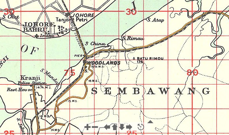
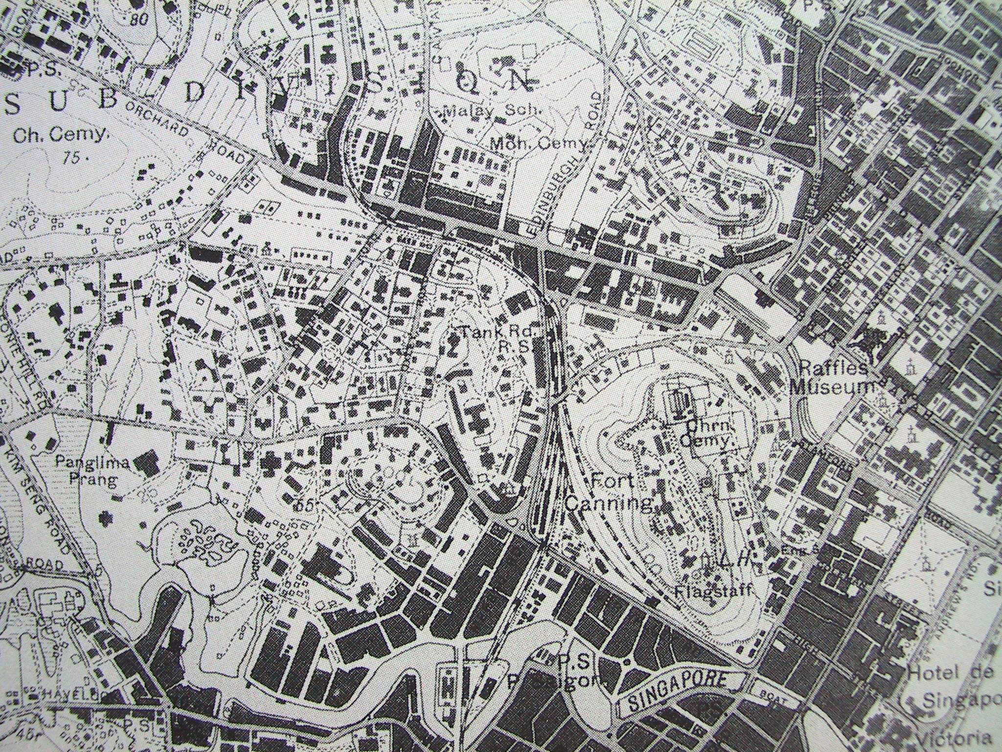
The Singapore - Kranji Railway, also known as the Singapore Government Railway and the Singapore - Johore Railway at various times, was constructed between 1900 and 1902 under the supervision of C.E.Spooner, the General Manager of the Federated Malay States Railway and was opened from the Singapore terminus in Fort Canning Park to Woodlands in two sections, Singapore to Bukit Timah on the 1st January 1903 and Bukit Timah to Woodlands on 10th April 1903. Total length at this time was officially listed as 14 miles 79 chains, however there are some reports which state 16 miles, this being due to the extra mile taken by the wagon ferries from 1910, the extra distance from Woodlands to the Wagon ferry, and extra distance to the Woodlands goods yard. For clarification it has to be mentioned that the island of Singapore contains numerous districts with the same names being used for towns and villages and in the case of Singapore for the Island and the City. Johore is included also as railway ferries operated between Woodlands and Johore. At Woodlands station there was a pier from the platform to the passenger ferry jetty for the connection to the mainland in Johore. The first station, simply known as Singapore, was on the northern side of River Valley Road with the entrance opposite Damar Road and accessed via Back Road. Sidings ran alongside River Valley Road as far as opposite Read Road and the locomotive sheds and facilities were cut into the lower slopes of Fort Canning. From Singapore the line ran north-westwards and crossed Orchard Road by a bridge near Emerald Hill west of the Singapore Cold Storage by Cuppage Road. It continued northwards until reaching Newton station, near where Newton circus now is, and then ran along the north side of Bukit Timah Road, through Cluny station, just west of Adam Road, Holland Road station, and on to Bukit Timah station, which was across the road from Pei Wah Avenue, where the Halfway House stood in the 1960s. At Bukit Timah village the line turned north and ran via Bukit Panjang station, Mandai station and Kranji (district) to Woodlands station, which was at the southern end of the present causeway, the section from Bukit Panjang still being in use until 30th June 2011 as far as Woodlands new station. Newton station had a siding which ran across Syed Alwi Road, which in those days started at Newton but later disappeared when Newton Road was built. In 1906-7 the line was extended southwards from a new station at Tank Road via Pulau Saigon bridge, Peoples Park (Chinatown) and Tanjong Pagar, and on to Pasir Panjang (at Chermin Bay) near Alexandra Brickworks. This I have not been able to identify but apparently there was a station near the junction of Alexandra Road, Telok Blangah Road and Pasir Panjang Road. Sidings were built into the docks at Tanjong Pagar and Keppel Harbour. This extension was opened on 21st January 1907. At this time there were stations at Passir Panjang (1907 spelling on the nameboards at that station), Borneo Wharf, Tank Road, Newton, Cluny Road, Holland Road (for the rifle range), Bukit Timah, Bukit Panjang and Woodlands. Total length of the line is stated as 19¾ miles, in which length are 55 gate-crossings, including 23 public level-crossings, where gatemen have to be maintained. In 1910 the line from Woodlands was extended to a Goods ferry jetty, the ferry being equipped to carry both goods wagons and locomotives to connect with the new Johore Railway which had opened in 1909. In 1914 the FMSR made arrangements for a new goods shed on the site of the old station and station masters house which had already been demolished. At the same time FMSR announced that the goods station on Pulau Saigon would be closed when the new one opened at Tank Road. In 1920 work was started on the relocation of the original engine and carriage sheds, and turntable, onto the remaining parcel of land west of the Pasir Panjang line in the area bounded by Tank Road and River Valley Road. Fuller details are in the 1920 Annual Report. Most of the line was built on a 60' wide strip of land known as the Railway Land as it belonged to the railway company, however in parts of the city this was reduced to 40' as 60' was not possible. Within these limits small deviations could be made without recourse to further approvals and over time a number of deviations were made on account of flooding following heavy rain and this was particularly bad alongside the Bukit Timah Road. At the Newton end the whole line had to be raised and moved further away from the river which was widened and deepened by effectively converting it to a canal throughout most of its length from Bukit Timah to Newton. With the opening of the new deviation the Tanjong Pagar some of the Railway Land was handed over the the PWD for new roads but the section between Cluny and MP 9 was kept for a while as there had been a plan to build an extension to tap the growing residential areas to the north-east of Cluny but this soon fell through once Tanjong Pagar had taken over from Tank Road as a terminus and this land was also handed to the PWD for road building.
Following is a more detailed and up-to-date report.
The first railway in Singapore was built by the Tanjong Pagar dock company in 1877 and ran along their wharves. It was operated by two locomotives supplied by Dick & Stevenson. Next came the Singapore Steam Tramway in 1885. This closed by 1894 and the stock was disposed of to the Tanjong Pagar Dock Company and Penang Steam Tramway. The Singapore Railway Line was built from Singapore station, opposite Damar Road at the southern foot of Fort Canning and ran to Woodlands Station which was located on the coast opposite Johore. It was mooted as early as the 1860s, approved by the Legislative Council in 1899 and completed in 1903 at a cost of $2 million. Management of the Singapore Railway operations, buildings and land were transferred to the Federated Malay States Railway (FMSR) in 1918 for over $4 million. The Malayan Railway Administration predecessor of Keretapi Tanah Melayu Berhad was established in 1948. The terminus in Singapore was the Tanjong Pagar Railway Station.
Plans to build a railway line through Singapore, primarily to service the New Harbour (later known as Keppel Harbour) were mooted as early as 1869 by Engineer W. J. du Port of the Tanjong Pagar Dock Company, but they only built a mile length of track which ran along the seaward side of the coal sheds and came into use in 1877. An early plan showed it extending to a station on Collyer Quay but this never happened although over the years this dock railway expanded such that it had a greater mileage of track than the 20-odd miles of the eventual Singapore Railway at its height. The final Singapore Railway project was approved by Governor Charles Bullen Hugh Mitchell only in 1899 after then Governor Cecil Clementi Smith raised the need for it in an 1889 Legislative Council meeting. Construction works were then initiated, with the ground-breaking ceremony held on 16 April 1900. Chinese labour was employed principally.
Between 1889 and 1899 it stagnated for about 5 years and then a traffic survey started followed by a route survey. Initially 3 areas were selected for the terminus while the promoters wanted it to be as close to the commercial district as possible. The three areas were Kandang Kerbau, Dhoby Green and Fort Canning. The route surveyor recommended Kandang Kerbau in his report as the other two involved additional works but the promoters rejected it as being too far from town and Dhoby Green was difficult to get to without a lot of buildings and official grounds in the way so the promoters asked for Fort Canning but did not like the Police Parade ground area but reluctantly agreed to it eventually (though during subsequent changes they tried to get approval for the empty site at the corner of Hill Street and River Valley Road). For whatever reason the Municipal Councillors of that period did not accept anything fronting onto River Valley Road.
The plan approved in 1899 had just three stations to be built as temporary wooded structures, being Singapore, Bukit Timah and Woodlands with flag stops at Scotts Road (later Newton station), Cluny, Holland, Bukit Panjang and Bukit Mandai. It is not clear whether the flag stations had platforms of any sort but at some point some at least reverted to full stations, with Newton having a loop (1905), platforms and a wooden building, Cluny Road having a loop (1904) and a building, and Bukit Panjang having a loop (1904).
C. E. Spooner, general manager of the FMSR, was appointed the supervisor of the project. Costing a total of $1,967,495, the Singapore-Kranji Railway Line, running from Singapore to Kranji, was completed in 1903. Opened in two phases, the first section was launched on 1 January 1903. It stretched from Singapore to Bukit Timah and consisted of four stations along the line: Singapore, Newton, Cluny and Bukit Timah. According to a newspaper report the following day a total of 557½ passengers were carried on the opening day. The second section, which extended the line to Woodlands, was completed three months later when the Woodlands station was opened on 10 April 1903. In 1903, there were a total of 426,044 passengers. By 1905, this had increased to 525,553.
Soon after, work began on the extension of the railway line across River Valley Road via a level crossing to the wharves at Pasir Panjang. Issues with the use of a level crossing at River Valley Road finally resulted in a decision to bridge this road with a 15 clearance bridge which was approved in 1905 along with a plan to build a new station further north alongside Tank Road with a rising embankment through the site of the original passenger station. In order to achieve this a new wooden station known at Tank Road station, was built without disrupting rail traffic and this opened in May 1906, after which the embankment was built through the old station site. The extension was completed and opened on 21 January 1907. With the extension, the stations along the line were Woodlands, Mandai, Bukit Panjang, Bukit Timah, Holland, Cluny, Newton, Tank Road, Borneo Wharf and Pasir Panjang. Not all the listed stations opened to passengers with the line. The existing goods and locomotive and carriage facilities remained unchanged at this time. Later another station or halt was made at Peoples Park for the residents of Chinatown. In addition further goods facilities were created on the island of Pulau Saigon. Increasing road traffic on Havelock Road may have been the reason for closing the goods sidings on Pulau Saigon and expanding the site north of River Valley Road and several plans were proposed. Initially a new and much larger station was to be built near Anderson Bridge, first at low-level and later at High level but objections to this saw another plan for a high level station above the old Police Parade ground area but in the end this area was used for low level but much enlarged carriage and locomotive facilities, and the old area was used for expansion of the goods facilities. Finally in the late 1920s came the plan to build a new line from Bukit Timah to Tanjong Pagar. Plans to extend the line along Boat Quay to Anderson Bridge or at least to Hill Street were finally abandoned in 1925.
For several years, the railway line operated two boats named Singapore and Johore which ferried railway passengers across the Johor Straits to visit the gambling dens in Johore. When the Johore Railway opened in 1909 these ferries carried railway passengers for connecting trains. With the completion of Causeway in 1923 a connection was made with the Johore Railway. Lodging flats known as the Kelantan flats in Kampong Bahru Road were built by the FMSR and provided accommodation for the Malayan Railway and Malayan Customs. The Tank Road-Bukit Panjang line was dismantled after the completion of the line to Tanjong Pagar on a new alignment via a new Bukit Timah station.
The Admiralty Military Railway was a line that branched off the main line near Woodlands and was built in the 1930's to serve the Naval Shipyard at Sembawang. Three of the locomotives were 0-6-0Ts built by Hunslet in 1929 and numbered SL18-20. In November 1941 they were transferred to the FMSR as the second Class A, later becoming 331 class before being sold to the Port Of Singapore in 1946. In addition to the metre gauge line there was a standard gauge system and two of the locomotives which operated this system were returned to the UK in 1955. One of these, Hawthorn Leslie 3865 of 1936, an 0-4-0ST named "Singapore", has been preserved. This line was closed in 1959.
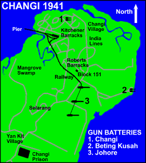
The Changi Military Railway was a 4-mile long standard gauge line built by the FMSR for the War Department, for the protection of Singapore's new Naval Base at Sembawang. The fortifications for the Naval Base were laid at the entrance to the Old Strait, at Changi, where one 15-inch gun, one 9-inch battery, one 6-inch battery and search lights were installed. The artillery installations were supplied with underground ammunition depots and loaded with armour piercing shells. On the beach, concrete machine emplacements and wire were installed. Airfields in Sembawang, Seletar and Tengah were to provide air cover for the Base. Bagnalls of Stafford supplied an 0-6-0ST, number 2547 of 6/1936, to the War Office department, Changi, Singapore. It had 16" x 22" cylinders and 3' 4" driving wheels. It was last seen derelict in 1947 but its fate is unknown. The railway ran from Fairy Point pier to the battery with a short branch to a depot. Further details are available from the Industrial Railway Society.
Other sidings involve the three which branched off the main line between Tanjong Pagar and Tanglin Halt, the exchange sidings for the latter being adjacent to Tanglin halt. The first was at TP 486/23 and very close to Alexandra Halt which I believe is incorrectly quoted as being at TP 485/20 while in fact it is shown on a map as being close to Alexandra Road just north of MP 487. this siding served a military depot alongside Depot Road. A short distance further on was the ABC siding which at one time extended well beyond the ABC premises to the Singapore Steam Laundry with further sidings branching off the the north for military purposes and quarrying. Then came the post-war Tanglin complex with exchange sidings to the north west of a new station completed around 1950 but closed by 1970. This station appeared to have had either a passing loop or a long siding to allow trains to pass each other. There are theories that there was always a passing loop at Tanglin halt, the location of that being close to the later station, but there is no solid evidence that this was the case and it would not be necessary being so close to Bukit Timah which was a fully-interlocked station, the only one between Johore and Singapore. These military sidings were served by two Avonside Engine Company 0-6-0STs, 2030/1929 SL7 (yard No 144) and 2031/1929 SL8 (yard No 145), and a Bagnall 0-4-0ST 2770 of 4/1944, yard No 1729 from 1st January 1957. Prior to that date all military sidings had been operated by the Malayan Railway. Whenever these locomotives moved between depots they had to use the main line and a token had to be obtained from either Tanjong Pagar or Bukit Timah and returned promptly by road after the movement. A fourth line branched off south of Bukit Timah, near my old home at Jalan Jelita, ran westwards, then turned north and crossed Ulu Pandan Road and entered a depot at Buona Vista Battery (see map on Singapore Railway history page). North of Bukit Timah there was a siding near Rifle Range Road, a siding for Hume industries close to the point of the 1932 deviation and a siding to Mandai Quarry. There was a fourth siding to the ammunition depot at Kranji, closed in 1959 - I am not sure if this is the same siding which later served a Shell depot at Kranji. A 1946 map also shows two sidings at Bukit Panjang running into military areas but these appear to have been very short-lived. The line from Tanglin exchange sidings ran south and then west, crossing Portsdown road near a school and ending up in the military complex adjacent to Ayer Rajah road near the junctions with North and South Buona Vista roads. Details of locomotives can be found here. Part of the Ayer Rajah parts were later redeveloped into the new industrial park at Ayer Rajah in 1989.
The Sir John Jackson contract was to build the Naval Base at Sembawang and a large number of locomotives of both metre gauge and standard gauge were required. The construction required a huge quantity of granite blocks which were quarried from mountains in south Johore and shipped by rail down to the coast opposite Sembawang for loading into barges.
On 4 March 1966, the 19km line from Bukit Timah to Jurong Port Road via the Jurong railway station, and Teban Gardens was officially built, this was a joint venture between the KTM and Economic Development Board. This has been closed down in 1986.
The Singapore railway is typical of British colonial railway systems, built to the metre gauge (3 ft 3⅜ in). Singapore had KTMs only hydraulic buffer stops developed by Ransomes & Rapier, a British manufacturer of railway equipment. The Singapore station was also one of three major signal cabins along the West Coast Line until 1967, when a new station was opened in Butterworth, Penang. Singapores Tanjong Pagar station was also only one of three stations with hotels, the other two being Ipoh and Kuala Lumpur.
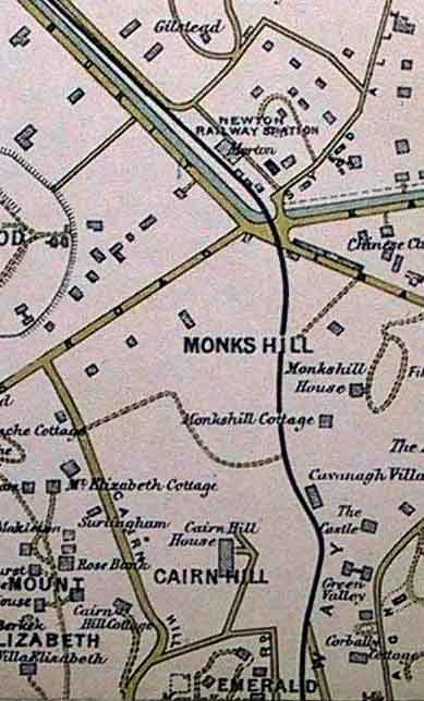
The railway track in Singapore ran along the current Cuppage Road, along the Monk's Hill Road and toward a station at Newton on Gilthead Road close to where the Newton Mass Rapid Transit (MRT) Station now stands. The tracks travels towards the Bukit Timah Road, with a stop at Cluny Road and Bukit Timah before passing through the Bukit Timah village to Kranji and Woodlands. An extension for goods trains was opened in 1907. This connected Tank Road Station to the dockyard in Pasir Panjang, via the Peoples Park area. There would be slowdowns at Bukit Timah and Kranji for manual exchange of tokens.
In 1970s, the electrification and double tracking was planned by the Singapore government to facilitate growth in public transit, and with the new commuter rail line, more new stations will be added and Metro-Cammell commuter rail trains will then be purchased similar to those in Hong Kong. One consequence is that whereas much of the track that is in the Malaysian railway is unfenced, with footpaths or roads alongside major villagers, the faster, quieter and more efficient railway requires the complete fencing of the railway from Woodlands to Tanjong Pagar, necessitating the construction of footbridges with both steps and sloping ramps at various village locations. A study from Harvard University had denoted stations such as Lower Delta, Alexandra, Buona Vista, Bukit Timah, Upper Bukit Timah, Bukit Panjang, Mandai West, Kranji and Woodlands Checkpoint with a possible extension to Jurong East and Tampines via the reclaimed land of East Coast. However, the idea was scrapped by 1990 as it was expensive to justify the idea and the two governments in Singapore and Malaysia wanted to move the railway station over to Woodlands Train Checkpoint, which was achieved on 1 July 2011. The section between Bukit Panjang and Bukit Timah Railway Station duplicates the Downtown Line Stage 2, which was opened on 27 December 2015.
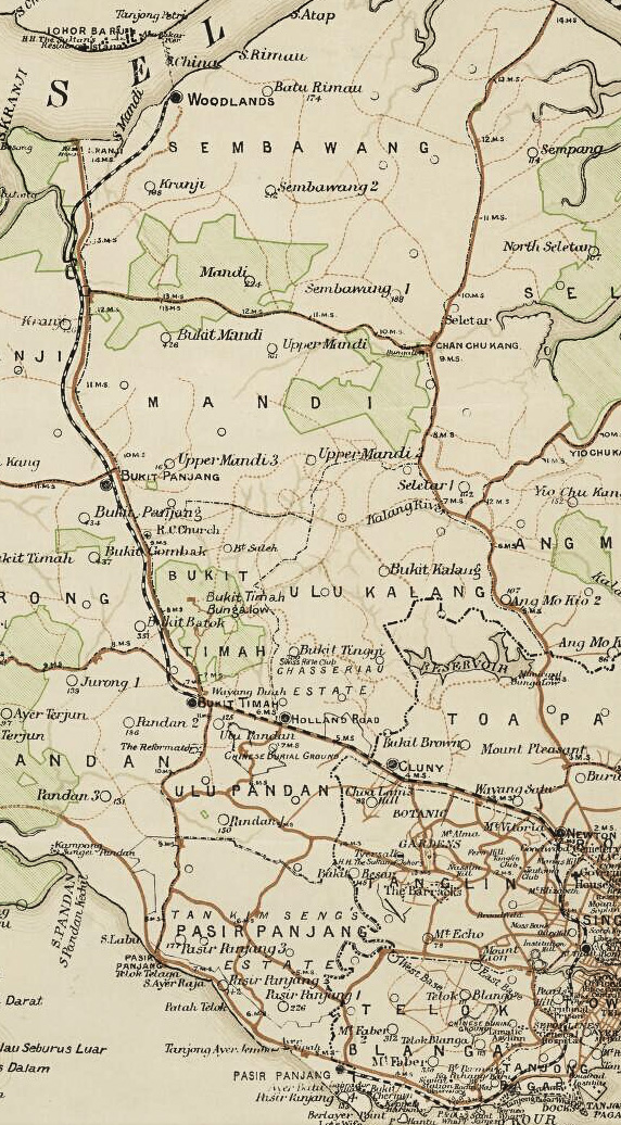
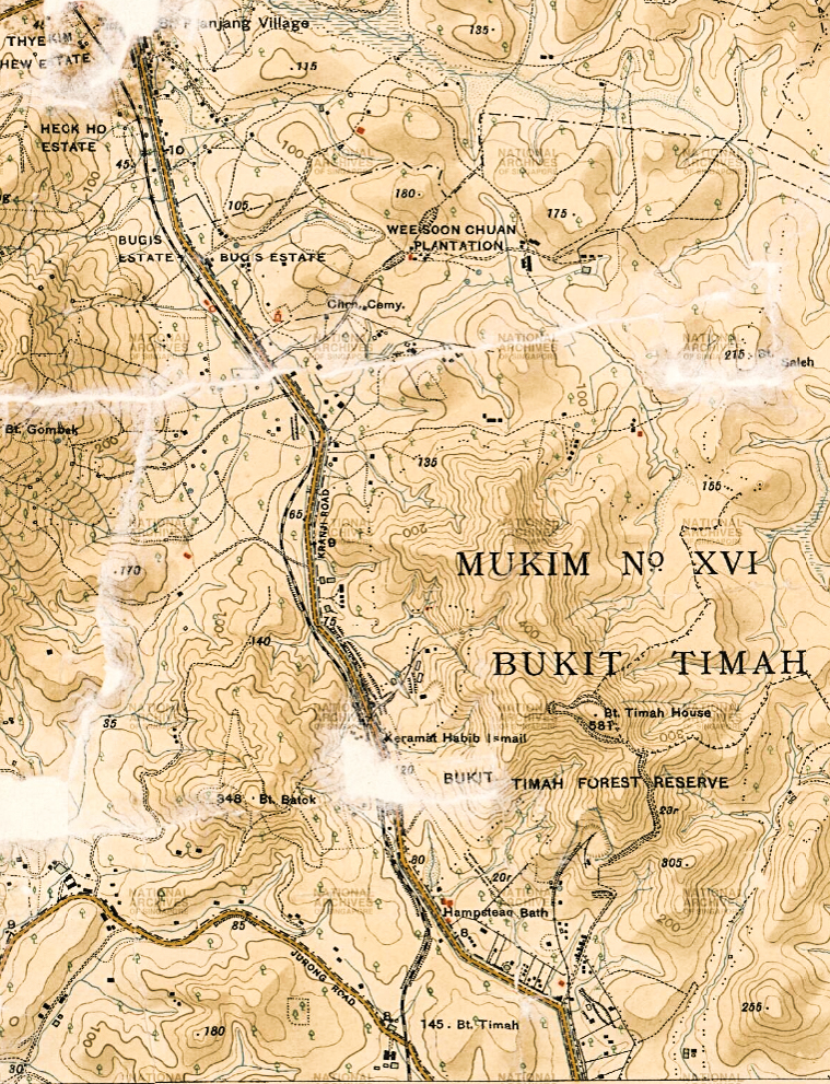
Above: This map shows the extent and route of the line from 1907 until 1923 when the causeway opened and also the ferry crossing to Dakar pier in Johore. The northern section from Mandai to Woodlands was realigned in 1926 and bypassed the old Woodlands station.
![]() Below: A map showing the line immediately after the
causeway was opened showing the sharp curve into Woodlands station and the
winding route round the hills near the junction of the old Kranji and Woodlands
Roads. The cutting to straighten out this section can be seen. Within a couple
of years a new alignment had been built bypassing Woodlands station and a little further inland
at the Woodlands end, but curving south-westwards to cross the original
alignment and run straight until the Mandai River which it crossed on a new
bridge NW of the old one, then turning southwards, again on a new alignment
until rejoining the original alignment at the Pang Sue river bridge. This was
completed in 1926.
Below: A map showing the line immediately after the
causeway was opened showing the sharp curve into Woodlands station and the
winding route round the hills near the junction of the old Kranji and Woodlands
Roads. The cutting to straighten out this section can be seen. Within a couple
of years a new alignment had been built bypassing Woodlands station and a little further inland
at the Woodlands end, but curving south-westwards to cross the original
alignment and run straight until the Mandai River which it crossed on a new
bridge NW of the old one, then turning southwards, again on a new alignment
until rejoining the original alignment at the Pang Sue river bridge. This was
completed in 1926.

![]() Above: The original alignment between Jurong Road and
Bukit Panjang in 1924.
Above: The original alignment between Jurong Road and
Bukit Panjang in 1924.
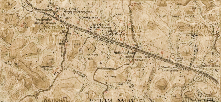
Below: The line between Jurong Road and the city running through Holland Road station and on towards Cluny in 1924. Note that this map is for some unknown reason missing the lower portion of Upper Bukit Timah Road, or what was known at the time as Kranji Road.
Singapore and Kranji Railway station opening and closing dates
Singapore 01 Jan 1903 (Thu) This
was the first station, by Fort Canning Hill on the triangle of land bordered by
River Valley Road, Tank Road and Back Road,
closed 30th April 1906.
Newton 01 Jan 1903 (Thu),
closed 2nd May 1932 (Mon).
Cluny Road 01 May 1903 (Thu),
closed 2nd May 1932 (Mon).
Bukit Timah (old) 01 Jan 1903 (Thu),
closed 2nd May 1932 (Mon).
Bukit Panjang 10 Apr 1903 (Fri).
No local timetables found since 1918.
Listed in 1947 Working Timetable but not
listed in 1958 Working Timetable.
Woodlands (old) 10 Apr 1903 (Fri).
Ceased to be used when causeway
opened to Passenger trains on 1st October 1923.
Eastern goods yard remained in
use.
Holland Road 16 Jul 1903 (Thu), closed 10 March 1930. Holland Road was listed in the original plan but did not open when the line first opened.
Tank Road 1 May 1906 (Tue),
closed 2nd May
1932 (Mon).
Borneo Wharf 21 Jan 1907 (Mon). Sunday only
service from 1st May 1912, not listed in 1918 timetable.
Pasir Panjang 21 Jan 1907 (Mon).
Closed to passengers by April 1912, last
advertised service found 30th June 1911.
People's Park 01 Apr 1908 (Wed). Sunday only service from 1st May 1912, not listed in 1918 timetable.
Mandai halt (old) at MP 476 65ch was open by 1918 (in 1918 timetable change). Closed 3rd February 1924. Bukit Mandai station was listed in the original plan but did not appear in early timetables.
Mandai (new) 3rd February 1924 at MP 477 57ch, station with a passing loop. Not listed in 1958 Working Timetable.
Singapore (Tanjong Pagar) 2nd May 1932 at 5.15 pm (Mon), closed 30th June 2011 (Thu).
Alexandra halt (TP 486/20) 3rd May 1932 (Tue). Closed 20th March 1934. Newspaper report says TP 485/20 but map shows it close to MP 487.
Tanglin 3rd May 1932 (Tue). No local local passenger services by 1958 but still in use for goods traffic and occasional military specials.
Bukit Timah (new) 3rd May 1932 (Tue), closed 30th June 2011 (Thu).
Kranji (1m 79ch S of Johore Bahru) was in Working Timetables but not in Passenger timetables. Maybe a military halt as near junction for naval base branch. Photographs show a platform and small building, while Allan Stanistreet reported that tokens were exchanged here.
Woodlands (new) 1st August 1998 for southbound passengers only. 1st July 2011 line from Tanjong Pagar closed to all traffic to and from Tanjong Pagar, line closed and lifted. Now only used for passengers to and from Malaysia.
* Holland Road was first indicated in the
Singapore and Kranji Railway timetable effective 1903 Jul 16.
* Tank Road was first indicated in the Singapore and Kranji
Railway timetable effective 1907 Jan 21, previous timetable showed
Singapore, as displayed on the station nameboards. It had actually been in use,
though not completed, since 1st May 1906 as the original station was in the way
of the embankment to a bridge over River Valley Road where the original plan was
for a level crossing.
* People's Park was first indicated in the Singapore and Kranji
Railway timetable effective 1908 Apr 01.
* Mandai first appeared in the 1918 supplement, which showed the first full timetable since April 1912.
I have copies of Singapore Railway timetables for various significant dates between 1903 and 1911 and FMSR timetables for 1912, 1917, 1918, 1920 and 1930. These show that initially services ran between Singapore and Bukit Timah with two extended to Woodlands when that section opened. When the Pasir Panjang section opened most trains were extended to that station and there was one daily service between Pasir Panjang and Tank Road, which replaced Singapore station on the same day. At first goods traffic was attached to the passenger trains but later there was a daily goods train in each direction. Passenger traffic on the Pasir Panjang line was never heavy and the service soon dwindled and had stopped by 1912 but freight was healthy and the line stayed open even after the Tank Road to Bukit Timah section had closed and eventually most of it passed to the port authority who had their own extensive railway system. I understand the Tank Road to Tanjong Pagar section closed by 1939 but Borneo Wharf to Pasir Panjang section was used by the Port Authority until much later.
The 1912-1920 construction works related to the creation of the Empire Dock at Tanjong Pagar caused a huge amount of disruption to the line from Tanjong Pagar to Pasir Panjang and also to the road network. The road and its attendant tramlines were realigned first while the railway was used for the construction work and at the finish the railway between those two points was in a completely different location when the works were finished. The tramway had taken all the passenger traffic but the realigned railway continued to have heavy freight traffic and at some point it became a part of the Singapore Harbour Board's own system. A series of 16 large scale survey maps in 1924 (FMS Survey 7) show the alignment of the full line at that time as far as Johore Bahru. The section from the Causeway to Mandai was itself realigned in 1926.
Links to timetables for the following dates:
| Singapore Railway | 1903 | 1904-1906 | 1907-1908 | 1909-1911 | FMSR | 1912 | 1917-1918 | 1920 | 1932 |
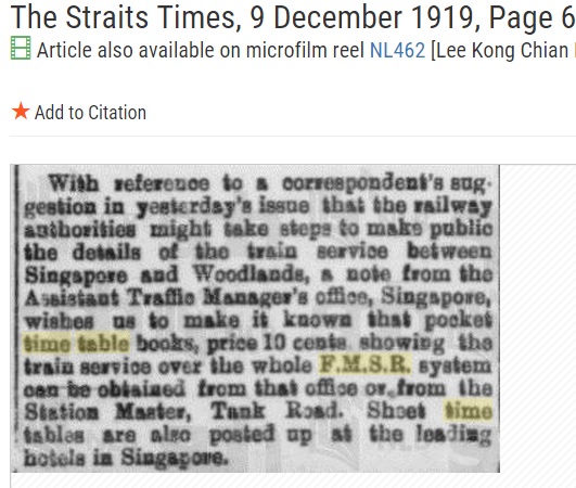 |
So, has any reader ever come across any of these? Quite likely they have all long since been discarded so another big slice of history has been lost forever. My guess is that 10 cents in 1919 was an awful lot of money. Regular local travellers would have no need of these pocket timetables and visitors could get their information from their hotel.
|
Three A class 4-4-0T locomotives built by Hunslet were supplied in 1901 with a fourth in October 1903. They were capable of pulling 99 tons up a gradient of 1/100 at 15 mph. Two similar but more powerful locomotives of B class were supplied in April 1906 and May 1907, these being capable of hauling 160 tons under the same conditions. A third B class locomotive was supplied by Hawthorn Leslie in 1911. In 1907 there were 25 passenger coaches and 46 six-ton goods wagons.
These same type of locomotives were also supplied to various railways in Malaya and other parts of the world from the 1880s. All were the same basic design but had minor detail differences. All those in Malaya and Singapore were incorporated into the FMSR by 1912 and although none of these have survived one which was sold originally to the Valencia Tramway Company in Spain was later sold to the FESA railway in Tortosa, Spain, where it was still at work in the 1960s. When the line closed in 1969 the locomotive was preserved in a local park where it is still well looked after.

The Singapore Government Railway operated independently up to 31st December 1911. On 1st January 1912 the operation was transferred to the Federated Malay States Railway. The Singapore Railway Transfer Ordinance of 25th October 1918 authorised the sale of the Singapore Railway and its associated land to the Federation of Malaya for the sum of S$4,136,000. It also authorised the construction of an embankment or causeway across the Johore Straits.
I heard in June 2005 that there was a station called Borneo park (2006 update - it is Borneo Wharf) near Breeze Hill in Tanjong Pagar, shown on a 1923 map, in the V formed by Keppel Road and Nelson Road. The same map also shows a Peoples Park station at approximately the spot where Pearl Bank school now stands (or did in 1963 & 1975). These were both on the railway to Pasir Panjang, opened in 1907. A 1905 map showing the railway between Breeze Hill and Orchard Road shows only one station on a short spur approximately where the Van Kleef aquarium later stood. Later maps, including 1913 and 1923, show Tank Road station further north, between Penang Lane and Tank Road (now Clemenceau Avenue), and the spur to the earlier station just as a siding. Thanks to Nadia Wright for this information. In fact the original 1903 station was where the National Theatre later stood but this later became the goods or engine yard and a new station was built about 1906 on what is now the site of the Haw Par centre for the opening of the extension to Pasir Panjang. A 1930s map shows Holland Road station where Ascot Rise now is, at the junction of Holland Road and Bukit Timah Road, just over 6 miles from the town centre. The same map does not show either Cluny station or Newton station. Nadia has also sent me a reference to Holland Road station on 16-11-04. There is a 1930 map which shows the line from Orchard Road to Tanjong Berlayer and also the course of the proposed deviation to Bukit Timah. No other stations are shown on this map. My 1946-54 map shows the line from Tanjong Berlayer still in situ as far as gate 7 but then remaining on the south side of Keppel Road and remaining in the docks area. The line from Breeze Hill is still intact also but instead of running into Tanjong Pagar station it now turns north to join the new line towards Bukit Timah. There is no connection from Breeze Hill to the old line south of Keppel Road. Can anyone shed any more light on these please. The Singapore Government Railway was purchased by the FMSR in 1912 as an isolated line. There may have been stations other than those mentioned but I can find no information as yet. I have just come across another map, dated 1907, which shows the line from Cluny to Pasir Panjang in very good detail, but it only shows stations at Cluny Road, Newton and Tank Road. It is possible that it was drawn before the extension opened.
July/September 2006 update - I have been sent some more old maps, one dated 1898 showing the proposed route of the railway continuing west and then north-west from Dunearn Road near where Jalan Jurong kechil now is to a point near the western extremity of Bukit Batok park, then turning sharply north-east to join the present route just north of the bridge across Upper Bukit Timah road, to the south of Bukit Panjang. The other is a 1925 FMSR map showing stations and distances as follows: Kempas Halt 464½, Tampoi 467¾, Johore Bahru 472, Woodlands 473¾, Mandai 477¾, Bukit Panjang 479, Bukit Timah 482¼, Holland Road 483¼, Cluny 485, Newton 487, Tank Road /Singapore 488¼, Tanjong Pagar 490¼ and Pasir Panjang 493¼. This is the first time I have heard of a Mandai station. There is no mention of Borneo Wharf station. Yet more maps recently arrived - it shows a station on the Pasir Panjang branch in the same location as the present Tanjong Pagar station. I have since determined that this was overlayed on an old map to show where the new station would be but there was no need for a station there as Borneo Wharf station was only a short distance away. At approximately the point where the current entrance to Tanjong Pagar station now is there was a branch leading off south-eastwards across Keppel road into the docks. This is shown on a 1923 map of the docks. The original Bukit Timah station was on the site later occupied by the Halfway House night club and restaurant close to the junction of Jalan Jurong Kechil and Upper Bukit Timah Road, opposite Pei Wah Avenue, and nowhere near the present line.
The original Woodlands station was parallel to the coast with the station building on the north side immediately west of where the causeway was later built and a covered walkway from the eastern end went out to sea for a short distance to a jetty for foot passengers. From October 1903 these passengers were ferried across to Abu Bakar pier which was opposite the Johore Hotel. This appears to have been where the causeway was later built. From about 1910 the line was extended some 100 metres east to a jetty for goods wagons . These were taken across on another ferry to the Railway pier in Johore, which was located east of where the causeway was later built. Over time a large yard was built up between the causeway and the old goods wagon jetty and beyond and in early 1942 this was used to store all the locomotives brought over from the mainland during the Japanese invasion of Malaya. Admiralty road was later built along this alignment but at first was named Naval Base Road. The Naval Base branch was built along the south side of this road at the same time (1926/7) as per this map.
Some minor alterations were made at Mandai to add a passing loop and a little further north a cutting was made through a hill which the railway had previously gone around in the 1920s. The railway was realigned in 1926/7 to cater for the Woodlands road deviation of that time and also to build the new branch line for the future Naval Base.
There was also a station at Kranji, it is shown in the 1958 Working Timetable as 1m 79c from Johore Bahru. There is a 1927 map which shows the route of the line and stations (I have yet to see it). One copy is for sale at the Antiques of the Orient in Tanglin Shopping Centre for S$7,000. There may well be a copy available for viewing in the British Library in London - I understand photocopying is not permitted but tracing is! I now have some copies of segments of a map which shows the alignment of the tracks and positions of the stations from 1926 to 1945, and also a full description of the changes carried out in the 1926 realignment between Bukit Panjang and Woodlands which explains where the original alignment was.
December 2007 update on the Tank Road to Tanjong Pagar line.
This line closed some 75 years ago but over the last few days I have been looking to see if any trace is left of it. Surprisingly, I have found that it is possible to walk almost the entire length of the old route. This is partly because new roads were built over the trackbed but in many places very little has been built and the original earthworks can still be seen. From Penang Road through to Havelock Road the whole route has been covered by Clemenceau Avenue and the only evidence is the earthworks around Fort Canning. If you stand on the Oxley flyover (yes, there is a footpath across it) and look north you are looking at the site of Tank Road new station (1907-1933). If you turn round and look south you are looking at the site of the old Singapore station (1903-1907) alongside River Valley Road opposite Read road, which later became the goods yard and running sheds. South of Havelock Road there is a housing block which you can walk through the middle of (between 51 & 53) and you come to the east side of Pearl's Hill where Pearl's Hill Hostel appears to have been built along the trackbed. Beyond here the railway swung right slightly and crossed Eu Tong Sen Street and New Bridge Road at an angle of about 45 degrees, roughly opposite Kreta Ayer Road and entered what is now Duxton Plains Park where a footpath has been laid approximately over the track bed and this curves gently to the left until it reaches Yan Kit Road. At the mid point of this section the path passes under Neil Road, via the old railway bridge, there may have been a level-crossing here at one time (the old line had 53 of these). After crossing Yan Kit road the line started to swing westwards passing through the site of the now disused Yan Kit swimming complex, across Cantonment Road and along where Cantonment Link is to the car park at Tanjong Pagar.
Today (30 December) I walked the section from Tank Road to Newton. Part of the old embankment is still in place between Buyong Road and Killiney Road behind the car park next to Penang Road. All traces of the bridge were removed during construction of Somerset MRT station and the corner of Robinsons obscures where the railway went, I walked along Emerald Hill Road to just after Hullet Road, then down an alley between the houses on the east side and behind the houses is the route of the old line. I walked back to where a door lead through a building and out on to Orchard Road. Going northward from here there is a path at the foot of what appears to be the embankment for a while, then you have to go through the new tunnel beside Clemenceau Avenue which you then follow to Newton Circus. Any traces on this last section have been obliterated by all the road works.
A number of maps showing the line from Bukit Panjang to Pasir Panjang via Tank Road have surfaced over the years and most of them differ to a certain extent on the precise alignment of the line. I have now obtained some partial copies of cadastral maps showing the precise alignment and have also received more photographs of the Orchard Road area and a few other places.
Click here for a large scale map of the Tank Road area showing basic track layout and bridges
Click here for a map of the track layout at Fort Canning in 1906
Click here for a colour map showing the line between Bukit Timah Road and Borneo Wharf
Click here for an early map showing the line from Tank Road to Newton.
Click here for a map showing the layout in the Tank Road area c1906/7.
Click here for details of the early Singapore Railway locomotives.
In 1919 construction of the Singapore-Johore causeway commenced and the railway from Woodlands to Johore Bahru, 54 chains long, was opened to goods traffic on 17th September 1923 and passenger traffic on 1st October 1923. The causeway was officially opened by Sir Lawrence Guillemard, Governor of the Straits Settlements, on 28th June 1924.
In the 1920s plans were drawn up for a Naval Base to be built at Sembawang and hence a branch line and new road would be built from Woodlands to serve this facility. At the same time the railway and road from Mandai to Woodlands would be upgraded. While the railway was more or less direct the road was very winding and prone to accidents. It was decided to build a new deviation for the road which would use the railway track-bed from the 15th mile. A new concrete railway bridge was built over the Sungei Mandai to take two tracks and the branch line to the Naval Base left the main line at this point but continued parallel to it as far as Woodlands, both on a new alignment slightly further west than previously. At Woodlands the two tracks crossed the old alignment and bypassed Woodlands station which was no longer used, the main line crossing the causeway and the branch running alongside the new road to the Naval Base, about 4 miles distant. This project started in 1926 and was scheduled to take 6 months.
Also in the 1920's plans were made to build a new terminus in Keppel Road and this was completed in 1932. The 8 miles 52 chains deviation line from Bukit Timah to Keppel Road station was opened to traffic on 3rd May 1932. This 1924 map shows the layout at that time, with a 3-way split under Kampong Bahru road bridge with the left hand track going eastwards as a goods siding, the centre track continuing to Tanjong Pagar station and the right hand track going southwards across Keppel Road and continuing as the Pasir Panjang branch, presumably for freight traffic to the various wharves and also to connect to the extensive dockyard system around Empire dock (Track not shown). The area around Borneo Wharf station then became part of the new goods yard. This is how the layout appears on a 1945 map. The original line from Tank Road to Bukit Timah was dismantled by 1936 (not shown on 1936 map) and some of the track-bed converted to Roadway, being Penang Road and Clemenceau Avenue from Tank Road to Newton circus and Dunearn Road between Cluny and Bukit Timah. Going westwards from Newton station the track was between the canal and Dunearn Road up to the point where the latter ended. The actual point where the deviation commenced would appear to be about a mile south of Bukit Panjang village, this point being 8 miles 52 chains from Keppel Road according to the official route mileage chart.
On 30th April 1932 FMSR had published a notice in the Sin Kuo Min Ri Bao newspaper announcing that Tank Road, Newton, Cluny and Bukit Timah (old) Railway Stations would be closed permanently on the night of 2nd May 1932 (Monday), after the last train left Tank Road at 8:30 pm for Kuala Lumpur. The new Keppel Station was officially opened by Governor Sir Cecil Clementi at 5:15 pm on 2nd May 1932. The grand event was held at the station main hall. Before that, the Governor accompanied with the Sultan of Perak and other guests boarded a special train from Bukit Panjang via the new route to the new station. I have a very poor quality copies of the photographs at the new station, the 3 coach train appears to be hauled by one of the then brand new S class pacifics which had taken over the Singapore to Taiping expresses. The following stations: Singapore, Alexandra Halt, Tanglin and Bukit Timah were opened from 3rd May 1932 onward. On 3rd May, the daily first train from Singapore departed for Kuala Lumpur at 8:30 am. There is no mention of Holland road station being closed so it had probably been closed earlier although it was still mentioned in the distances tables in 1925. The new timetable published for 3rd May 1932 onwards does not show Mandai, Kranji or Woodlands stations so these had probably also closed by this time, at least to passenger traffic. This timetable shows only the Gemas and Kluang all-station locals, one of each each way, stopping at Bukit Panjang and Alexandra Halt. There were 3 trains each way between Kuala Lumpur and Singapore and these stopped at Tanglin and Bukit Timah with the exception of the northbound Night Mail which ran non-stop from Singapore to Johor Bahru in 36 minutes.
On 11th November 1965 a branch was opened from Bukit Timah station to the new Jurong Industrial Estate but much of the expected traffic did not materialise. In all my visits to Jurong in the 70's, working in the various shipyards, I only ever saw one train, hauled by a 201 class diesel, and the shunting loco in the cement works. There was a 3 coach passenger train hauled by 20114 at the opening and the ceremony was attended by 20104 bedecked in flags. I also have a copy of a picture depicting 563.04 shunting there shortly afterwards. The last steam locomotive left Singapore in late 1972.
In 1961 the Singapore Harbour Board had 16 miles of tracks in its 950 acre site, which were connected to the main line west of Tanjong Pagar station. By the 1970's it had been renamed to the Port of Singapore Authority and owned a number of diesel shunters. I have some maps showing the system at various times, and hope to be able to show them later. There is some more information on my Industrial page.
The main railway yards were located at Kranji, Bukit Timah and in the city between Keppel Road and Kampong Bahru Road. Adjacent to the latter two branches ran off the main line into the docks (see above). Other branches ran off at various places to industrial estates or military installations and the locations of these have been obtained from a number of different maps over the years.
![]() The following are details of some of these sidings taken
from original working timetable appendices covering charging scales for the use
of such sidings:
The following are details of some of these sidings taken
from original working timetable appendices covering charging scales for the use
of such sidings:
Siding for Ewart and Co. (Civil Engineers), Singapore, (Hindhede quarry) at 480m 55ch between Kranji and Bukit Timah.
Siding for the Military Authorities (Exchange sidings) at Tanglin.
Siding for Archipelago Breweries at Telok Blangah siding at 486m 21ch between Tanglin and Singapore.
Siding for the Military Authorities (Alexandra Base Ordnance Depot) at 486m 75ch between Bukit Timah and Singapore.
175 Mandai quarry Siding at 477m 34ch between Kranji and Bukit Panjang.
177 Singapore Hume Pipe Company's siding at 480m 65ch between Bukit Timah and (Cluny Road) but this should be Bukit Panjang. Cluny Road closed in 1932 and Hume factory opened in 1941.
179 Municipality siding at Newton.
181 Singapore station to Telok Ayer reclamation or to any dock siding or line situated in the Singapore Harbour Board premises beyond Singapore station or vice versa.
The 4 mile long Changi line was built by the FMSR for the War Department to a gauge of 4' 8½" for the construction of the Singapore Defences. This line ran from Fairy Point pier, turning south-eastwards to clear the east bank of Sungei Selarang, following an alignment similar to where Aldergrove Road now is and crossed the Upper Changi Road close to the 13 milepost (21 km post now). After this it turned west of south to the 15" gun emplacements (known as Johore Battery) east of Lloyd Leas estate. The map below shows more detail and clicking on the map will take you to the site I obtained it from with a fuller history. My thanks to Margie Hall, the KTM railway fan club and the unknown author of this site for the above information. If they will contact me I can give them due credit.

A British Library interactive map of the Changi base dated 4.5.33 can be viewed here. It shows full details of the standard gauge railway and also a 2' gauge railway system
The branch from Queenstown to Ayer Rajah Industrial estate only shows on maps from the mid 1990's and that of 1946, but not those in between, while those from Bukit Panjang and Kampong Kranji are only on the 1946 map.
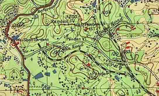
There was a supply line to the Buona Vista Battery near the corner of Ulu Pandan Road and Clementi (ex-Reformatory) Road. This left the main line opposite my house at 41 Jalan Jelita and headed in a westerly direction, keeping about a couple of hundred yards south of Ulu Pandan Road until a little way short of Reformatory Road when it turned north crossing Ulu Pandan Road and stopping at the foot of the hill just to the north. The battery had 2 15" guns, presumably on top of this hill, which were apparently destroyed by the British when the Japanese took control. My thanks to "dataxbox" for supplying this information and maps, part of which is reproduced below. Any further details of this or any other lines would be welcome, please e-mail me, address below.
Click here for an update on Military Railways.
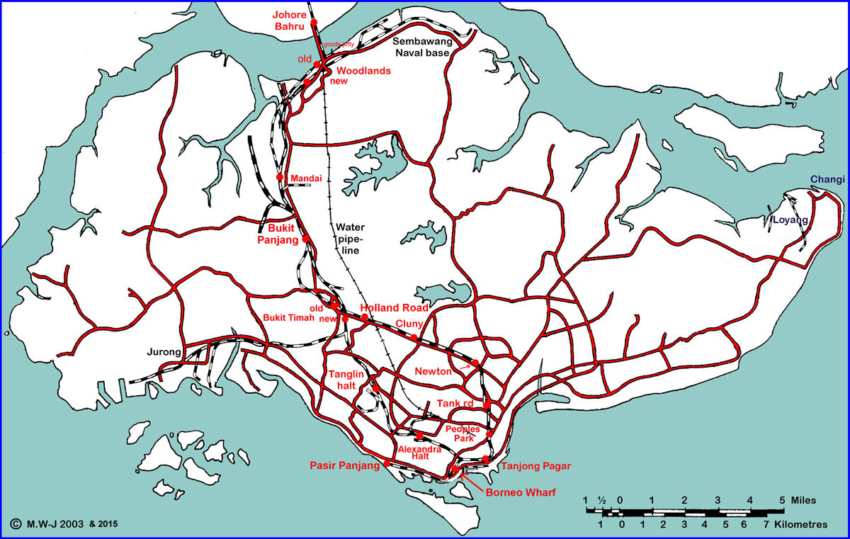
The map above is not strictly to scale nor accurate in either positioning or date, but merely gives an indication of the approximate location of the various lines described above. Indeed, the line from Bukit Timah to Jurong was not built until some 30 years after the line from Bukit Timah to the docks via Tank Road had disappeared. The present Woodlands station was only opened some 10 years ago, when the Customs and Immigration facilities were transferred there from the Keppel Road terminus at Tanjong Pagar. Passenger trains ceased running to and from Tanjong Pagar in 2010 and all trains start and terminate at Woodlands for Customs and Immigration formalities. Tanglin halt has also disappeared as have the majority of branches shown. All track south of Woodlands has now been lifted and the causeway link will also be removed by 2020 The Changi line is now more correctly positioned, please see text above map, which I have now redrawn. The station previously shown as Borneo Park is actually Borneo Wharf. The terminus station of the dock branch from Tank Road (opened to traffic 21st January 1907) is Pasir Panjang. I now know the approximate location of the original Bukit Timah station, close to Jalan Jurong Kechil, now buried under the PIE. The original Woodlands station was a little way north-east of the present station, at the southern end, and immediately west of the causeway. The original line turned sharply northwards at the eastern end of the platform but a few years later a new deviation was built along the line of the former road from Woodlands to Mandai bridge. Bukit Panjang station was close to Bukit Gombak, between lorongs 4 & 5. At the opening ceremony the new Singapore station at Tanjong Pagar was referred to as Keppel Station in one newspaper and the timetable showed an Alexandra Halt and a Tanglin Station. Does anyone know the precise location of Alexandra Halt.
A number of Industrial concerns had steam locomotives, the largest being the contractors for building the Naval Base and Kallang Airport. Click here for a full list of steam locomotives known to have been sent to Singapore.
From the timetable headings it was known as Singapore & Kranji Railway from December 1902 to April 1903, Singapore and Kranji Railway from May 1903 until April 1909 and as the Singapore Government Railway from May 1909 onwards. In January 1904 The Straits Times referred to it as The Singapore Johore Railway. After 1912 it was known as the FMSR Singapore section.
W. Tearle was Manager from 1903 (initially pro. tem.) until at least 19th January 1907.
J. H. Williams was Manager and Engineer by September 27th 1907 until at least 1909 and perhaps 1910 or later.
W. J. Haskins was Acting Manager and Engineer by July 1st 1911.
The following links will take you to pages containing more than 650 photographs taken on the railways of West Malaysia (formerly Malaya) and Singapore between 1962 and 2016, the majority between 1975 and 1977 when my back garden overlooked the line from Bukit Timah to Tanjong Pagar and I was working in the port areas of Loyang, Jurong and Singapore.
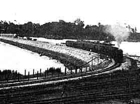
A handful of pictures taken between 1962-1965, includes 2 steam on the causeway.
Pictures taken between 1972-1977 in Singapore and Malaysia, includes dumped and preserved steam.
From my back garden: Pictures taken in 1975 in Singapore. + Pictures taken in 1976 in Singapore.
Pictures taken from my garden and at Tanjong Pagar, April-June 1977.
Pictures taken from my garden, at Bukit Timah and Tanjong Pagar, July and August 1977.
Pictures taken between Singapore and Penang in 1985, includes the KTM Centenary celebrations.
A brief visit to Singapore station area on 4th February 2003, plus a surprise.
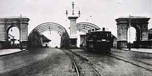
Above left: The original Singapore station of 1902 between River Valley Road and Fort Canning. Above right: Orchard Road bridge in 1925.
A larger version of this picture, another picture of the same station from the top of Fort Canning and several pictures of the new Tank Road station appear here.
There is a detailed map of the layout around Fort Canning in 1924 here.
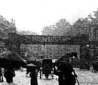
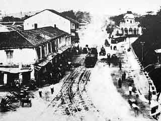
Below: Tanjong Pagar Road looking towards the docks from the junction with Anson Road in 1892. In the centre is a steam tram with trailer. Details of steam trams.
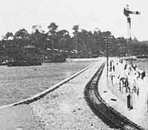
Above: The causeway from Johore (left) and Singapore (right).
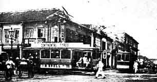
Below left: High street / North Bridge Road junction. Below right: Anderson bridge.
National Heritage Board, National Archives of Singapore.
Brian Raybould, military railway engineer.
Margie Hall.
The KTM Railway Fan Club (website).
Nadia Wright.
"dataxbox"
Peter Chan
Tim Light
The 2Bangkok.com Railway History forum (website).
Penang Trams, Trolleybuses & Railways by Ric Francis & Colin Ganley
Singapore Trams, Trolleybuses & Buses by F W York & A R Phillips
Trevor Sharot
Others who wish to remain anonymous.

Last updated 20th January 2022.
First published 1990.
This page has been visited times.